Tuesday, May 10, 2016

Battle Axe Mountain


The trail starts at an unofficial trailhead where washouts have closed the forest road. This portion of the trail follows the creek that washed out the road. You will reach what was the original trailhead, Trail #3340, and start your climb up a more obvious and more maintained trail.

The trail on Battle Axe Mountain is a mixture of dirt and rocks. Most rocky areas are talus fields that the trail crosses a few times as it switchbacks up the mountain. You will notice multiple rock formations and a diverse array of geologic formations in addition to wildflowers (if you hike in the spring) and stunning views. On a clear day you will be rewarded with views of Mount St. Helens, Mount Rainier, Mount Adams, Mount Hood, Mount Jefferson, Mount Washington, Three Fingered Jack, Broken Top, and the Three sisters.


The trail on Battle Axe Mountain is a mixture of dirt and rocks. Most rocky areas are talus fields that the trail crosses a few times as it switchbacks up the mountain. You will notice multiple rock formations and a diverse array of geologic formations in addition to wildflowers (if you hike in the spring) and stunning views. On a clear day you will be rewarded with views of Mount St. Helens, Mount Rainier, Mount Adams, Mount Hood, Mount Jefferson, Mount Washington, Three Fingered Jack, Broken Top, and the Three sisters.

A cabin was built on Battle Axe in 1925. It was replaced by a tower in 1951, but this was destroyed in 1969. Concrete pillars are all that remain from the site. There is room for a tent here or at a couple other areas along the trail, but there are no actual designated campsites. From the summit, return back the way you came or follow along the ridge to return on Trail #544.
Note that the trailhead has space for about four cars, and the road is rough. If you do choose to park at the unofficial trailhead, you will need a high-clearance four-wheel drive vehicle. For other parking options, try parking further down the road or at the campground. There is no marker indicating the trailhead.


Thursday, January 7, 2016


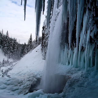
Tamanawas Falls hike is a easy year round hike. Today I hiked, rather snowshoed, to the waterfall. The hike is just under 4 miles round trip and gains about 500 feet elevation total. You are almost never out of eyes sight of the river and you hike. This adds to the beautiful setting with small waterfalls and just the beauty that the snow brings. Once you see the waterfall it is just breathtaking. The ice surrounding it is blue and it is something to marvel at. I brought my crampons and very thankful I did. The area around the waterfall is a sheet of ice so I used the crampons to hike up and behind the waterfall. Be careful doing to though and there was snow and ice falling at times. This hike can get very packed especially on the weekends.


Friday, January 1, 2016


Starting at Maxwell Butte snow park take the trail in front of the bathrooms. Follow the trail to marker 9 and turn right and walk a short distance to marker 10 and turn left. You will start gaining a small amount of elevation at this point but it is not steep. You will come to marker 12 and you keep going straight. You will find some points to catch some views. But the views get better if you keep going the short distance to the shelter. Once you reach the mountain view shelter you will be greeted with not only great views but maybe someone who is visiting the shelter. There are no reservations needed to stay ing the shelter and it fits around 15 people. There is a wood burning stove inside to keep you warm or help you cook your food. The net elevation gain is 600 feet and there are plenty of other trails you can explore or leave the way you came.