Showing posts with label hiking. Show all posts

Thursday, January 7, 2016


Tamanawas Falls hike is a easy year round hike. Today I hiked, rather snowshoed, to the waterfall. The hike is just under 4 miles round trip and gains about 500 feet elevation total. You are almost never out of eyes sight of the river and you hike. This adds to the beautiful setting with small waterfalls and just the beauty that the snow brings. Once you see the waterfall it is just breathtaking. The ice surrounding it is blue and it is something to marvel at. I brought my crampons and very thankful I did. The area around the waterfall is a sheet of ice so I used the crampons to hike up and behind the waterfall. Be careful doing to though and there was snow and ice falling at times. This hike can get very packed especially on the weekends.


Friday, January 1, 2016


Starting at Maxwell Butte snow park take the trail in front of the bathrooms. Follow the trail to marker 9 and turn right and walk a short distance to marker 10 and turn left. You will start gaining a small amount of elevation at this point but it is not steep. You will come to marker 12 and you keep going straight. You will find some points to catch some views. But the views get better if you keep going the short distance to the shelter. Once you reach the mountain view shelter you will be greeted with not only great views but maybe someone who is visiting the shelter. There are no reservations needed to stay ing the shelter and it fits around 15 people. There is a wood burning stove inside to keep you warm or help you cook your food. The net elevation gain is 600 feet and there are plenty of other trails you can explore or leave the way you came.


Saturday, December 26, 2015

Trillium Lake: xc skiing and snowshoeing adventure


Trillium lake is a popular destination to get out and enjoy the day any time of year. I like going in the winter to enjoy a beautiful day in the snow. Great for xc skiing and snowshoeing around the 3.6 mile loop you get a beautiful view of Mount Hood once you reach the lake. This is a popular rest area to take pictures of the lake and Mount Hood, eat a snack and take a picture of a gray jay landing on you. The loop is mainly flat with small hills and is dog friendly.

You must have a snow park permit in your car window or you may get a fine. The parking lot can get very busy and I have seen cars parked too close making it a challenge to get out of your parking spot. 


Once you start down the trail from the parking lot you will go down a small hill. Once this flattens out you come to a fork in the road. You can go either directions because it is a loop. I always just stay left as with most of the visitors. You will see some trails going off the main loop but unless you know where you are going and planning going off the main loop, don't take them. Stay on the main loop and soon you will come to the lake. You can walk to the right of the lake to the dock or hang out along the path to take in the view of Mount Hood. During the winter months the lake will be frozen and snow covered. A bird called the gray jay lives in alpine regions and they know to hang out by the lake hoping to get fed. The will land on your hand if you hold out food for them. 


After you took in a snack and got you pictures, continue on your way. You will come to another area where you could take a wrong turn. Stay to the right on the main path. You will end up passing a few cabins along your way. They are beautiful covered in snow. When you come to a T in the trail, stay right. This will be at the big meadow. Look out for the tiny cemetery on your right if it is not completely covered by the snow. Not too much further and you reach the first fork in the road. Turn left here and you will walk up the hill back to the parking lot.

There is no bathroom so it is best to stop at Government Camp before hand. Don't forget water and dress in layers and weather appropriate. 


Saturday, May 30, 2015

Mt. Hood Summit

When a fellow hiker Noelle asked if I wanted to summit Mt. Hood I could not turn this opportunity down. I could not sleep at all that night after agreeing to go. Excited, nervous, fearful, I had several emotions rotating through me. After all, I had never climbed a mountain like this before. This was going to be epic for me, but being a mom I think I had more fear than many would because of the cost to my son and family if something went wrong. 


I had never actually met Noelle before. We met on our online hiking group and exchanged messages. We met that morning at 5 am in Sandy and drove together from there to Mt. Hood where we would meet up with her friend Jon. He has tons of experience climbing and had climbed Hood many times before so that made me feel safe. But what made me nervous was how late we were getting started during that day. Most people start in the middle of the night to get down before the sun warms the ice. The risk of falling ice, rocks or yourself increases the later you start. It had been hotter than normal already this year and the snow had been melting sooner than normal. But I pushed my fear aside and went with my excited emotion instead. We hit the trail at about 7:30 that morning.


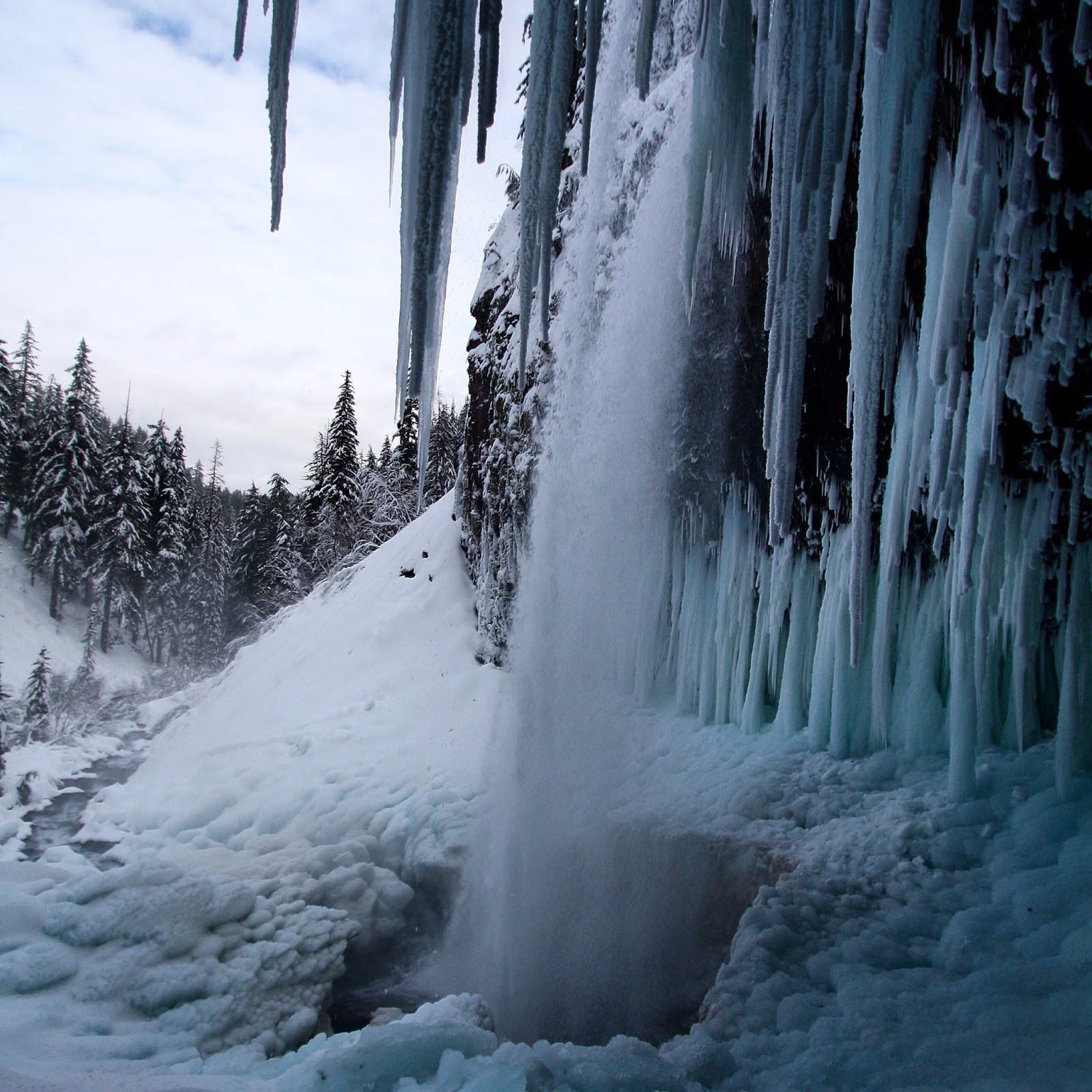
"Slow and steady" is what Noelle would tell me when I felt like I was slowing them down at all. It made me feel better. I did get some leg cramps at one point in my quads. I had been drinking a lot of water but probable not enough. Nothing a little gel pack of GU energy with amino acids and caffeine couldn't fix and I soon felt better. We climbed a little further and sat and ate a real snack before we started to head over to the hogs back. We had to pass our first crevasse and fumarole. It is kinda crazy to think that Mount Hood is always emitting volcanic gas. I know it is a volcano but it is alive and well. And you never really think about how alive it is because you just see it as Oregon's tallest mountain. It's a bit stinky up there too with the gas going out of it.

Fumarole
After climbing up the hogs back you have the large crevasse you have to go around. We saw a group of climbers who looked like they tried to climb up the pearly gates and were taking hours to come back down and around this crevasse. We thought about going up the pearly gates but there was just too much rock fall making it not the best route. Once getting to the other side of this crevasse it was time to make our way up the home stretch of the old chute.
Crevasse
Although the climb up this point was long and tiring, it was not difficult or what I felt, posed any danger. This last stretch up was the steeper part where I feel like I had to watch my step. This is where my crampons and ice axe got some use. Making sure I secured my toes into the ice and my axe down into the ice so I did not slip, I followed Noelle and Jon up to the summit.

Coming up the old chute
"I made it! Holy shit I made it! Oh my goodness!" It was beautiful. The view and the feeling inside me was beautiful. As I peaked my head up over the ledge and took a look around I felt overwhelmed and overjoyed I could not believe I was there. I just wanted to soak it in. We all congratulated each other and others who also made it to the summit.

Reaching the summit

The true summit


Mt. Adams, Mt. Rainier and Mt. St. Helen's behind me from the summit


Looking east from the summit
From where I first made it up on top I had to walk over to the right a little further to reach the "true summit". We took pictures and talked to others up there and took in the views. The man who climbed up behind me carried his skis up and had a parachute in his backpack. We watched him ski off the summit which was pretty epic. There where three guys who climbed up with their snowboards who snowboarded down the old chute. I was sure they where going to get hurt but to my surprise they made it down okay. That takes guts and skill cause it looked deadly to me.

We decided to rope up for the climb down the chute. Jon gave a little safety talk before going down. I don't really remember what he said but I remember teasing him about not giving it to me earlier. Getting turned around and taking that first step down was a little scary and awkward. I think it felt scary because I was going down backwards and could not see where I was stepping as well. I feel like this made me be more cautious about making sure my ice axe and crampons where secured into the ice with each step back down. We ended up climbing down to the "hot rocks" and walked across them to the hogs back. Just past the hogs back where we passed the first fumarole we encounter climbing up, we stopped for a few minutes. We took our rope, crampons, and helmets off and packed our things away in out backpacks. From here we glissaded down as far as we could and then walked our way back to the cars.


Climbing back down


My climbing partners John and Noelle on the summit
In all it took up about 12 hours. I really have to thank Noelle and Jon for such an amazing day. I overcame some fears and accomplished a goal. Now I have a list of mountains to summit. It kinda gets addicting.

Sunday, August 3, 2014

Mt. Jefferson


Jefferson Park is a stunning basin of alpine lakes and wildflowers at he base of Mount Jefferson. Once the blanket of snow melts in early summer, the wildflowers begin to bloom around July in a typical snow pack year. This makes July through September the best time to visit. 


Whitewater Creek Trailhead has parking for about 25 cars. The trail climbs through a dense forest of Douglas fir trees. Small sections of the trail cross boulder fields which you will have small boulders to walk over like stepping stones. After a few miles into the hike you will begin to notice the trees thin out and you are welcomed with views. Walking along a ridge you can catch views along the way such as Whitewater lake and Whitewater Creek Waterfall. You will come to a water crossing where you must walk through Whitewater creek. This is the only creek crossing without a bridge. The trail soon joins up on the PCT for the remainder of the hike into Jefferson park. You will get some stunning views of Mt Jefferson along the way with lovely meadows full of wildflowers. 

Once you enter Jefferson Park you will be treated to the amazing beauty of this area. The lakes offer views which reflect the mountain as if they are mirrors. Wildflowers abound and places to explore will have you wanting to visit again. This hike can be done as a there and back day hike or an overnighter.


Be aware that there are no campfires aloud. 

Adhere to trails as the vegetation is fragile.

Mosquitoes are no joke here so be prepared with spray. 

Camping is permitted in designated sites only.

Designated campsites  within 250 feet of a lake requires a reservation through reservation.gov. 30 sites around 5 lakes will be available. A reservation is required between Memorial day and October 1st with May 1st being the day reservations open.


You may camp in a pre-existing campsite outside of the 250 feet designated area if all campsites are reserved.